中四 試卷 (F4 Geography Past Paper)
編號:
6668
年級:
中四 (F4)
科目:
(Geography)
學校
檔案格式:
pdf
頁數:
3
檔名:
geog 201920_Form_4_DSE_Geog_CP2_CW_2.3_3X
▼ 圖片只作預覽, 如欲下載整份卷, 請按「免費成為會員」 ▼

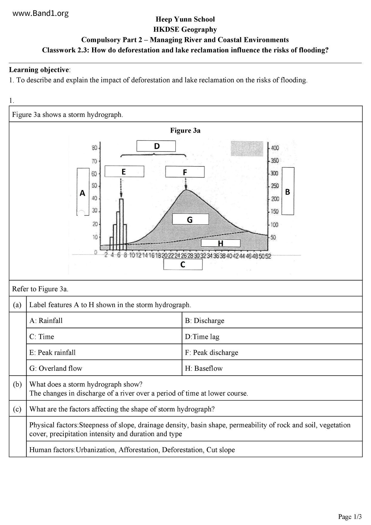
▲ 圖片只作預覽, 如欲下載整份卷, 請按「免費成為會員」 ▲
中四試卷 PDF 下載
下載試卷只限會員尊享
或
內容節錄:
Learning objective:
1. To describe and explain the impact of deforestation and lake reclamation on the risks of flooding.
Heep Yunn School
HKDSE Geography
Compulsory Part 2 - Managing River and Coastal Environments
Classwork 2.3: How do deforestation and lake reclamation influence the risks of flooding?
Figure 3a shows a storm hydrograph.
A: Rainfall
E: Peak rainfall
G: Overland flow
Refer to Figure 3a.
(a) Label features A to H shown in the storm hydrograph.
B: Discharge
F: Peak discharge
H: Baseflow
2 4 6 8 10 12 14 16 18 20 22 24 26 28 30 32 34 36 38 40 42 44 46 48 50 52
(b) What does a storm hydrograph show?
The changes in discharge of a river over a period of time at lower course.
What are the factors affecting the shape of storm hydrograph?
Physical factors:Steepness of slope, drainage density, basin shape, permeability of rock and soil, vegetation
cover, precipitation intensity and duration and type
Human factors: Urbanization, Afforestation, Deforestation, Cut slope
(a) Describe and explain the changes of a storm hydrograph before and after deforestation is being carried out.
Rising limb
Falling limb
Peak discharge
(b) How would the risks of flooding in a drainage basin change AFTER deforestation?
Higher risk of flooding
Overland flow increases → there are larger discharge and peak discharge after deforestation.
And then when the actual discharge is larger than the bankfull discharge → there will be a flooding.
Therefore, there will be higher risk of flooding after deforestation.
Overland flow increases → Basin slope soil erosion increases → river load increases
river bed / more silting. → bankfull discharge reduces → risks of flooding increases
Before deforestation
Extent of the lake before
reclamation 20 years ago
Lotus ponds
Figure 3b shows the change in the extent of a lake. Figure 3c is a storm hydrograph showing the discharge of the
main river channel.
Rainfall (mm)
After deforestation
increases → more deposition @
Time (hours)
Discharge (m³/sec)
Bankfull discharge
Discharge after reclamation
Discharge before
reclamation
Refer to Figures 3b and 3c.
(a) Describe the change in the extent of lake with reference to Figure 3b.
The extent of the lake has decreased drastically in size. The lake has become narrower as well
→ The water carrying capacity / water holding (storage) capacity of the lake decreases
(b) What human activit(ies) had led to the change as mentioned in (a) as shown in Figure 3b?
Lake reclamation.
(c) Describe the changes in the storm hydrograph AFTER the change in the extent of lake with reference to
Peak discharge is higher after reclamation.
Time lag is shorter.
The rising and falling limbs are steeper.
Increase risk of flooding.
In view of the change in the extent of lake, account for the risks of flooding around the lake and
downstream of the lake.
risk of flooding around the lake and downstream of the lake -> increase
Lake reclamation → → water carrying capacity/ water storage capacity of the lake reduces/ reduced ability of
the lake as a buffer to regulate floodwater / lower ability of the lake to regulate the river discharge -
(when there is a sudden increase in actual discharge from upstream) → risks of flooding around the lake
Lake reclamation → water carrying capacity/ water storage capacity of the lake reduces/ reduced ability of
the lake as a buffer to regulate floodwater / lower ability of the lake to regulate the river discharge
(when there is a sudden increase in actual discharge) → risks of flooding downstream of the lake increases